Jewish Quarter Map

This map of the Jewish Quarter highlights its rich Jewish heritage and the many excavations that uncover ancient Jerusalem and the layers of different periods in the city’s long history.

The Western Wall

Western Wall Tunnels

The Hurva Synagogue

Davidson Center

The Burnt House

Sephardic Synagogues

The Cardo

The Southern Steps

Wohl Museum

The Western Wall

The Western Wall Tunnels

Hurva Synagogue

The Burnt House

The Davidson Center

Four Sephardic Synagogues

The Cardo

The Southern Steps

The Wohl Archeological Museum

The Broad Wall

Built in King Hezekiah’s time (8th century BCE) to protect Jerusalem from the Assyrians, the Broad Wall is mentioned in Nehemiah 3:8. The prophet Isaiah also refers to the city’s defenses (Isaiah 22:9–10). This is a good example of how archaeology supports and confirms the accuracy of biblical history.

Robinson’s Arch

Robinson’s Arch is the remains of a massive stone arch that once supported a bridge leading to the Temple Mount. It was identified in 1838 by the American scholar Edward Robinson.

Google Map with Floating Carousel

Site 1

The Western Wall

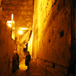
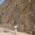
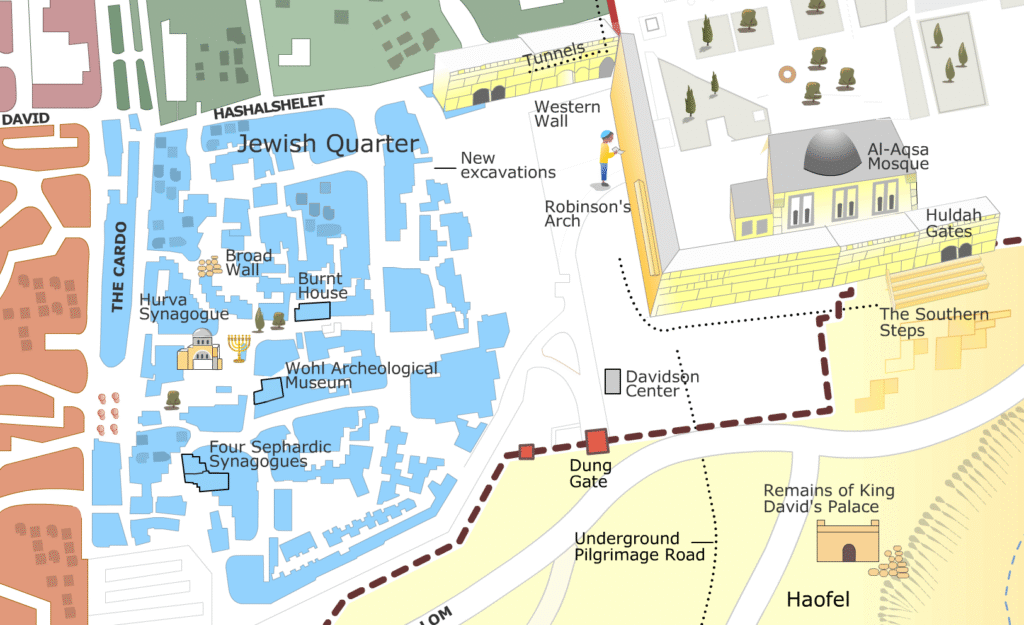
The Western Wall, also known as the Wailing Wall or Kotel, is one of the holiest sites in Judaism. The lower section of the wall was built by Herod the Great in the 1st century BCE as part of his grand expansion of the Second Temple in Jerusalem. While the Temple Mount had already been the spiritual and cultural center of Jewish life since the time of King Solomon, who built the First Temple nearly 1,000 years earlier, Herod significantly enlarged and reinforced the structure, creating the vast platform that remains today.

The wall stretches approximately 488 meters (1,601 feet), though only a portion is visible above ground. It is revered as the closest accessible point to the Holy of Holies, the most sacred part of the ancient temple.

For centuries, Jewish worshippers have gathered at the wall to pray, mourn the destruction of the temple in 70 CE by the Romans, and place written prayers in its cracks. The prayer area is divided into separate sections for men and women, following Orthodox Jewish tradition.

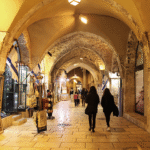
Today, the Western Wall remains a major pilgrimage site and a focal point for religious and national ceremonies, including bar mitzvahs, Jewish holidays, and Israeli military inductions. While it is a sacred site for Jews, it is also visited by people of all faiths, symbolizing both religious devotion and historical continuity.

Site 2

The Western Wall Tunnels

If you are planning a visit to the Western Wall, you may want to include the Western Wall Tunnels as part of your experience. Walking through these passageways feels like stepping into a time tunnel, where stones laid by King Herod still stand in place, hidden for centuries beneath the Old City. The tunnels reveal parts of the Second Temple complex that cannot be seen from the plaza above, making the history and tradition of this sacred place come vividly to life.

Excavations here are especially meaningful because digging on the Temple Mount itself is not possible. Until 1967, both this site and the Old City as a whole were under Jordanian control and inaccessible to Israel. For the Jewish people, and many others, the tunnels represent both an archaeological discovery and a deep expression of connection to history and heritage. For Christians, it is quite literally walking in the footsteps of Jesus, as the tunnels bring you down to the level of the streets that once ran alongside the Temple Mount — the very paths where Jewish pilgrims of his time would have walked.

The tour itself adds to the experience: narrow stone corridors, dimly lit walkways, and the sense of being surrounded by massive ancient blocks make the history feel tangible. Every turn in the passage reminds visitors how close they are to the very foundations of Jerusalem’s holiest site.

The tunnels expose the full length of the Western Wall, extending 485 meters, far beyond the 70 meters visible in the prayer area. Visitors can see massive Herodian stones, including the Western Stone, which is 14 meters (46 feet) long and weighs around 570 tons, one of the largest building stones in the world.

A significant stop in the tunnels is the closest point to the Holy of Holies, where many Jewish visitors come to pray. The tunnels also contain the Hasmonean Water Channel, an ancient aqueduct that once supplied water to Jerusalem, and the Struthion Pool, a large reservoir from the Second Temple period later covered by the Romans.

Ancient passageways, streets, and structures from different historical periods, including the Roman and Crusader eras, are also visible throughout the tunnels. Interactive 3D models and multimedia exhibits help bring the ancient city to life.

A newly opened tour, The Great Bridge Route, allows visitors to walk along a reconstructed section of an ancient bridge that once led directly into the Second Temple. This bridge was used by pilgrims and high-ranking officials, offering a glimpse into the grandeur of Jerusalem during the Second Temple period.

Access: The entrance to the tunnels is just to the left of the Western Wall plaza, near the covered area with security. Entry is only possible with a guided tour, which must be reserved in advance through the official website or at the visitor center (same-day availability is limited).


The Hurva Synagogue

Site 3

The Hurva Synagogue, one of Jerusalem’s most significant Jewish landmarks, was originally built in 1700 by Rabbi Yehudah Hachasid’s followers but was destroyed by Ottoman authorities in 1720 due to unpaid debts. Rebuilt in 1864 as Beit Yaakov, it became the main Ashkenazi synagogue in Jerusalem. The synagogue was demolished by the Jordanians during Israel’s War of Independence in 1948. In 2000, a reconstruction project began to restore it to its 19th-century design. Completed in 2010, the replica preserves its historical and religious significance. Today, the Hurva serves as a place of worship, study, and a symbol of Jewish resilience.

The Davidson Center

Site 4

The Davidson Center is an archaeological and educational complex within The Jerusalem Archaeological Park. It immerses visitors in the story of Second Temple-era Jerusalem, blending real ruins, ancient artifacts, and virtual reconstructions to reveal the sacred and civic heart of the ancient city.

It is located by the Dung Gate, just a short walk from the Western Wall and the Jewish Quarter, so a visit can easily be combined with these sites.

The center focuses on the southern area of the Temple Mount, where pilgrims would enter the Second Temple. Visitors can experience how ancient worshippers—ordinary people, priests, and even historical figures—approached and interacted with the Temple.

  • The Southern Steps – These original steps served as the main ascent route to the Temple Mount. They are deeply significant not only in Jewish history but also in Christian tradition, as Jesus, like other Jews of his time, would have walked on these very stones when visiting the Temple. This makes the site especially meaningful for Christian visitors, offering a tangible connection to the New Testament narrative.
  • The Hulda Gates – Located at the top of the steps, these now-sealed gates once served as the grand entrances into the Temple Mount. 
  • Robinson’s Arch – This area features the remains of a massive stone arch that supported a monumental bridge leading from Jerusalem’s Upper City into the Temple Mount. At its base is an ancient market street, complete with stone shop stalls and paving stones worn by centuries of foot traffic. Nearby lies a massive fallen cornerstone, believed to have been part of the arch, inscribed with the words “to the place of trumpeting”—thought to mark the spot where priests would announce the Sabbath or holy days. This unique inscription offers a rare and direct link to the ritual life of the Temple.
  • Ritual Baths (Mikva’ot) – Located near the entrances, these were used for purification before entering the sacred Temple area.
  • Indoor Multimedia Exhibits – The Davidson Center’s museum space includes 3D reconstructions of the Temple, digital timelines, and displays of coins, inscriptions, and everyday artifacts from the time of the Second Temple.

The Burnt House

Site 5

The Burnt House is a small but powerful archaeological museum located in Jerusalem’s Jewish Quarter. It preserves the ruins of a wealthy priestly home destroyed during the Roman destruction of the Second Temple in 70 CE. Excavated beneath street level, visitors can see ash-covered walls, charred beams, household items, and even the skeletal arm of a young woman—silent witnesses to the tragic end of ancient Jerusalem. A short video helps bring the story to life, offering an emotional window into the final days of the city.

Opening Hours:

Sunday to Thursday: 9:00 AM – 5:00 PM

Friday and holiday eves: 9:00 AM – 1:00 PM

Closed on Saturdays and Jewish holidays

Admission: Paid entrance; discounts available for children, students, and groups

The Four Sephardic Synagogues

Site 6

The Four Sephardic Synagogues form a historic complex that served as the spiritual heart of Sephardic Jewry in Jerusalem for centuries. Built between the 16th and 18th centuries, these synagogues—Yohanan ben Zakkai, Istanbuli, Eliahu Ha’navi, and Emtsai (Middle)—were used continuously until 1948, when the Jewish Quarter fell under Jordanian control. After restoration, they once again stand as a testament to the endurance of Jewish life, prayer, and tradition in Jerusalem.

Each synagogue reflects the heritage of different Sephardic communities, with unique architecture, Torah arks, and traditions. Today, they serve both as active places of worship and a museum-like complex that tells the story of Jerusalem’s Sephardic Jews.

Opening Hours:

Sunday to Thursday: 9:00 AM – 5:00 PM

Friday and holiday eves: 9:00 AM – 1:00 PM

Closed on Saturdays and Jewish holidays

Admission: Paid entrance (can be combined with a Jewish Quarter multi-site ticket); discounts available for children, students, and groups

The Cardo

Site 7

Walking in the Jewish Quarter, you will probably pass by an open lower street with rows of columns. This is part of the Cardo from Roman times. If you take the stairs down and walk straight north along it, you can observe how the street changed through different periods—from Roman to Byzantine and then Crusader. The image here shows the Cardo as uncovered from the Crusader period during archaeological excavations after 1967. Remains of shops from that era were preserved, and today are used as souvenir shops as part of the Jewish Quarter. As you continue further, the Cardo narrows as it becomes part of the local Muslim Quarter.

The Cardo was the main north-south street of Roman and later Byzantine Jerusalem. It was built by Emperor Hadrian after the Bar Kokhba revolt (132–135 CE), when he rebuilt the city as Aelia Capitolina and renamed the province of Judea to Syria Palaestina—a move meant to erase Jewish identity and history.

In the Byzantine period (4th–7th centuries CE), the Cardo was expanded and became a bustling commercial avenue lined with columns, shops, and market stalls. During the Crusader period (12th century), parts of the street were rebuilt and continued to serve as a central marketplace, some of it even roofed.

Today, restored sections of the Cardo allow visitors to walk along the ancient path, where Roman and Crusader remains are integrated with modern stores—offering a vivid window into the city’s layered past.

The name Palestine, as introduced by the Romans, had no actual connection to the ancient Philistines mentioned in the Bible. By Hadrian’s time, the Philistines had long ceased to exist as a distinct people. The Roman emperor chose the name Syria Palaestina—along with renaming Jerusalem as Aelia Capitolina—as a symbolic act intended to suppress the memory of Jewish sovereignty and sever the historical ties between the Jewish people and their land.

The name continued to be used in various forms by later rulers, including the Byzantines, Arabs, Crusaders, and Ottomans. During the British Mandate in the 20th century, it was used as a geographical term for administrative purposes.

The Southern Steps and Hulda Gates

Site 8

The Southern Steps, located at the southern wall of the Temple Mount, were the main entrance for pilgrims ascending to the Second Temple 2,000 years ago. Worshippers would enter through the Hulda Gates—a series of arched gateways named after the prophetess Hulda—and climb these broad, uneven steps in a slow, reflective approach toward the holy site.

Built during the Herodian period, the steps were intentionally designed with alternating long and short treads to create a natural rhythm of walking and contemplation. The gates led through underground passageways into the Temple Mount plaza.

Today, the Southern Steps are a powerful archaeological site, offering one of the few places where visitors can walk where ancient pilgrims once stood. The area provides striking views and a deep historical and spiritual connection to the Temple and Jewish heritage.

Notable Visit: Neil Armstrong
During a visit to Jerusalem, astronaut Neil Armstrong was guided by an Israeli archaeologist to the Southern Steps. He asked whether Jesus might have walked there, and when told these were original steps from the Second Temple period, he reportedly said:
“I am more excited stepping on these stones than I was stepping on the moon.”
This remark reflects the deep spiritual impact that this ancient site continues to have on those who visit it.

The Southern Steps and Hulda Gates are part of the Jerusalem Archaeological Park – Davidson Center.

Opening Hours: Sunday–Thursday 9:00–17:00, Friday 9:00–14:00

Tickets: Entry requires a paid ticket, available at the Davidson Center or online.

The Wohl Archaeological Museum

Site 9

After the Six-Day War in 1967, when Israel regained control of the Old City, archaeologists began excavating the Jewish Quarter, much of which had been destroyed during Israel’s 1948 War of Independence. Beneath the rubble, they uncovered remarkable remains from the Second Temple period.

The Wohl Archaeological Museum preserves these discoveries, showcasing the grand homes of Jerusalem’s priestly elite who lived near the Temple Mount. Visitors can see original mosaics, frescoes, ritual baths (mikva’ot), and household items that bring to life the daily world of ancient Jerusalem.

Opening Hours: Sunday–Thursday 9:00–17:00, Friday 9:00–14:00

Tickets: Entry requires a paid ticket, available on-site or through the Jewish Quarter ticket office

Mount of Olives

The outlook from the Mount of Olives offers one of the most iconic and breathtaking views of Jerusalem. From this elevated point, visitors gain a deeper understanding of the city’s history and its role as a holy center for faith and tradition.

Mount Gilboa

Mount Gilboa rises above the Jezreel Valley as the setting of one of the most dramatic moments in the Bible. According to 1 Samuel 31, it was here that King Saul, wounded in battle and seeing his sons — including Jonathan — lying slain in the valley below, fell on his own sword to avoid capture by the Philistines. Their bodies were later taken and hung on the walls of Bet She’an, visible from the slopes of the mountain.

This event is more than a battlefield tragedy—it marks a pivotal turning point in the biblical story. It reflects the complex relationship between Saul and David, the deep bond between David and Jonathan, and the divine choice to anoint David as the next king of Israel. In the following chapter (2 Samuel 1), David mourns Saul and Jonathan with a heartfelt lament: “How the mighty have fallen…”

This moment also marks the beginning of the rise of the House of David, the royal lineage of Israel’s future kings. Standing at Mount Gilboa, surrounded by the same landscape described in the Bible—the mountain, the valley, and nearby Bet She’an—you can feel the story come alive through the geography and the echoes of the ancient past.

Interactive map of Jerusalem Old City with religious and historical landmarks
Skip to content